Did You Know?
Sultan Muzaffar Khan, a ruler from the Bomba Dynasty, founded the city of Muzaffarabad in 1646
34°21'20.4"N 73°28'35.4"E
Sultan Muzaffar Khan, a ruler from the Bomba Dynasty, founded the city of Muzaffarabad in 1646
The Best Time to Visit Azad Kashmir Region is Summers. Preferably from April to September. Winters are Extremely Cold and Snowfall blocks most of access. Hence Winters are not recommended.

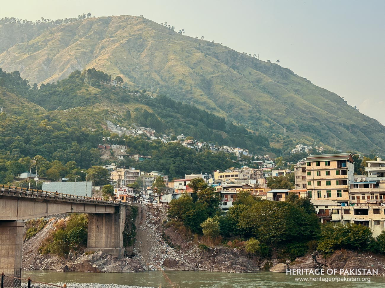
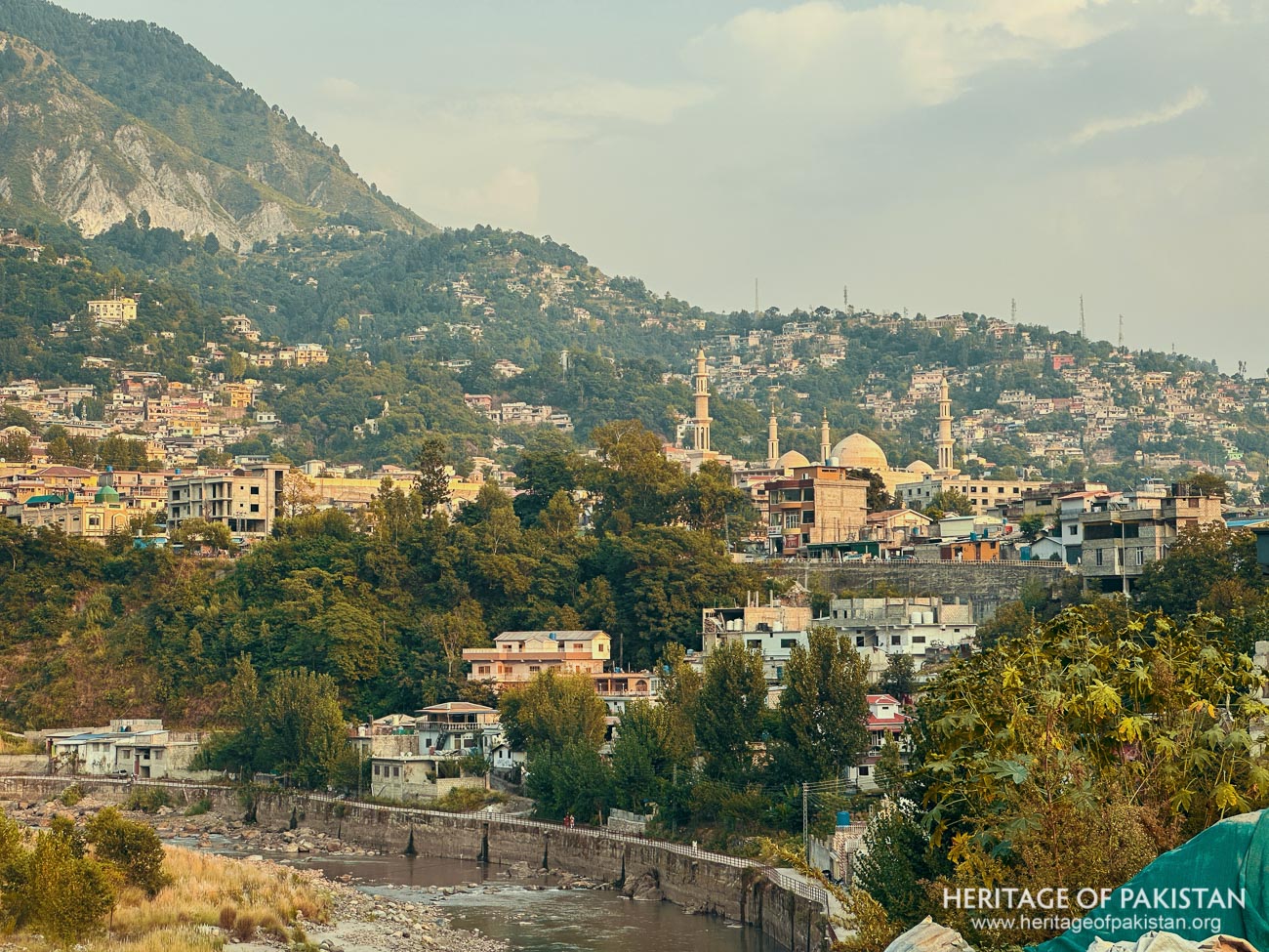
Muzaffarabad is the capital and largest city of the Self Governing region of Azad Kashmir. It is located at the confluence of the Neelum and Jehlum rivers. Situated approximately 136 kilometers from Islamabad, the capital of Pakistan, the city holds significant administrative and historical importance. Muzaffarabad serves as the headquarters for the Muzaffarabad Division and District, which includes the districts of Muzaffarabad, Neelum, and Hattian. The city plays a pivotal role in the region, both as a political center and a gateway to the picturesque tourist destinations in Azad Kashmir.
One of the most renowned attractions near Muzaffarabad is Neelum Valley, a stunning area that attracts visitors for its natural beauty and beautiful landscapes. Tourists typically travel to Muzaffarabad from Islamabad and then proceed to explore Neelum Valley, making the city an essential starting point for travelers. In addition to its natural allure, Muzaffarabad is home to several religious and historical sites, including the famous Pir Chanasi shrine. Located near Muzaffarabad on a hill, the shrine is dedicated to the famous saint Sayed Hussain Shah Bukhari and draws pilgrims from various parts of the region. Muzaffarabad also hosts the Baradari of Ranbir Singh, a historic building associated with the era when Kashmir was under Sikh rule.
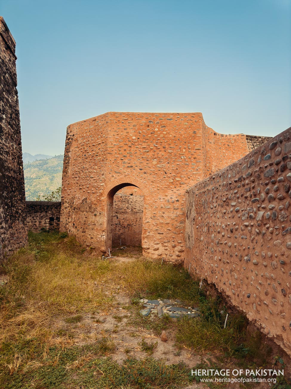
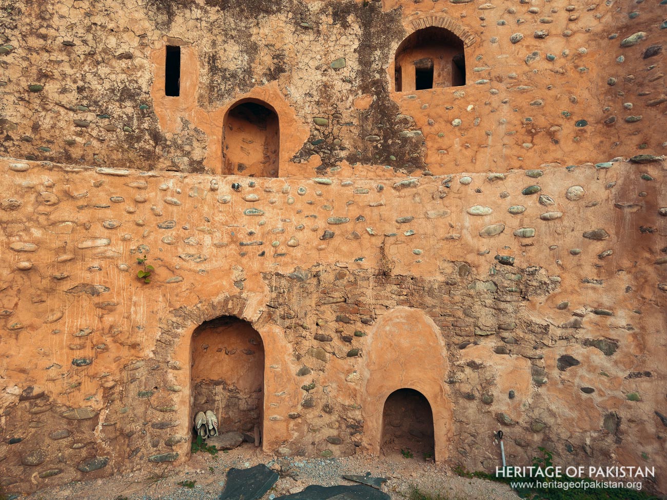
Muzaffarabad's history is closely intertwined with the iconic Red Fort, a symbol of the region's military and political history. The fort was originally constructed by the Chak Dynasty in 1559 as a defensive structure amid rising tensions with the Mughal Empire. The Chaks ruled Kashmir from 1554 to 1582, but after their defeat by the Mughals, Kashmir was annexed by Emperor Akbar in 1586. Sultan Muzaffar Khan, a ruler from the Bomba Dynasty, founded the city of Muzaffarabad in 1646 and established the Red Fort as a military base. Recognizing the fort’s deteriorating condition, Sultan Muzaffar Khan undertook significant repairs and reconstruction, transforming the fort into a formidable military stronghold once again.
In 1846, the Dogra Dynasty, led by Maharaja Gulab Singh, took control of the fort. Understanding its strategic importance, Maharaja Gulab Singh initiated extensive renovations, further expanding the fort's structure. The reconstruction continued under his successor, Maharaja Ranbir Singh, and the fort took into the form it retains today. The Red Fort remains a key historical landmark and an enduring symbol of Muzaffarabad’s history. It is currently managed by AJK Tourism & Archaeology Department which has restored this amazing fort.
Today, Muzaffarabad is home to a population of approximately 686,000 people, a vibrant mix of different ethnic groups. These include Gujar, Rajput, Mughal, Awan, and Kashmiri tribes, each residing in distinct localities within the district. This diversity contributes to the city’s rich cultural fabric. As the primary trade center of Azad Jammu and Kashmir (AJK), Muzaffarabad plays a vital role in the region’s economy and continues to be a hub for commerce and trade. Its blend of historical significance, cultural richness, and strategic location makes Muzaffarabad a city of great importance in the region.
The city's cultural and spiritual significance is further highlighted by the shrines of several prominent Sufis, including Saheli Sarkar, Shah Inayat Wali, Shah Hussain Bukhari, and Pir Alam Shah Bukhari, among many others. These shrines are not only places of worship but also attract visitors seeking spiritual solace, adding to the city's religious diversity and heritage.
Muzaffarabad, the capital of Azad Kashmir, is strategically located at the confluence of the Jhelum and Neelum rivers. The climate of the city varies significantly depending on the region. The northern part of Muzaffarabad district experiences cooler temperatures compared to the southern areas. During the month of July, the mean maximum temperature is around 30°C, while the minimum temperature is about 20°C. In contrast, January sees much colder temperatures, with a mean maximum of 16°C and a minimum of -6°C. The average annual precipitation in the district is approximately 1511mm, contributing to its lush environment.
The district is characterized by mountainous terrain, with valleys and terraces that are extensively used for agriculture. The fertile land supports the cultivation of a variety of crops, including maize, wheat, rice, oilseeds, potatoes, pulses, and a wide range of vegetables. Additionally, Muzaffarabad is well known for its fruit production, particularly apples, walnuts, pears, plums, and apricots, which are grown in abundance.
Muzaffarabad is also rich in forests, which cover about 59% of the district’s area. These forests play a vital role in the local economy, serving as a major source of income for the residents. The forests are home to a diverse range of tree species, including coniferous varieties such as Deodar, Blue Pine, Fir (Spruce), and Chir, as well as broad-leaved trees like Walnut, Ash, Maple, Poplar, Willow, and Oak. These resources not only sustain the local economy but also contribute to the region’s natural beauty.
All Photographs by Syed Noor Hussain and Sania Azhar.
All Rights Reserved. Photos may be used for Non-Commercial, Educational, Artistic, Research, Non-Profit & Academic purposes.
Commercial uses require licensing agreement.
Syed Noor Hussain
July 23, 2025 at 4:01 amBest